
If a picture is worth a thousand words, how many words are two pictures worth? Long time Chicagoans looking at the picture on the right taken in 1963 should immediately recognize Stateway Gardens, the high rise buildings on the upper right of the photo, and old Comiskey Park on the upper left, with the Dan Ryan Expressway and the New York Central/Rock Island Railroad tracks separating them. The expressway has been around so long that now folks take it for granted. Like it or not, it is a crucial transportation conduit for the entire metropolitan region and today it would be impossible to imagine the city without it. Likewise for the tracks which have been around way longer than anything else in the photograph; nobody thinks much about them at all, one way or the other. Stateway Gardens which date from the same time as the expressway on the other hand, stir up a whole bag of opinions, mostly negative.
Some believe that the buildings known today as "housing projects" were built as a means to concentrate poor people into an easily manageable, contained and segregated space, out of sight and out of mind as far as the rest of the city was concerned. Others say the political establishment at the time relished such a concentrated block of citizens whose votes could be easily procured and manipulated.
Whether there is merit to those opinions or not, there is no question that the experiment of high rise projects built to house the poor was an unmitigated failure. The buildings, originally a highly sought after clean and modern refuge from the slums they replaced, eventually came under the control of gangs who terrorized residents who would not cooperate with them. Crime skyrocketed and poverty stagnated. Things got so bad that firefighters and other emergency personnel refused to enter the buildings without police escort. The projects became places where hope came to die.
Stateway Gardens and the larger Robert Taylor Homes just to the south, formed the longest unbroken chain of high rise projects in the world. Just barely over forty years after they were built, most of Chicago's major housing projects were demolished in favor of low rise, scattered site, mixed income housing. The last building of the Stateway/Taylor amalgam, was demolished in 2007.
Stateway Gardens and the larger Robert Taylor Homes just to the south, formed the longest unbroken chain of high rise projects in the world. Just barely over forty years after they were built, most of Chicago's major housing projects were demolished in favor of low rise, scattered site, mixed income housing. The last building of the Stateway/Taylor amalgam, was demolished in 2007.
It's easy to overlook the fact that these developments were considered at the time they were built to be a progressive, dare I say cutting edge approach to housing. I've written before about the two major twentieth century movements to rethink the way we built our cities. Cities, the reformers insisted, were over-crowded, dirty cesspools of filth and disease, which led to social ills such as crime and poverty. They could only be improved, so they said, by drastically rethinking the way we approached their design and planning.
 The photograph on the left, made from exactly the same vantage point as the one above, perhaps fifteen years earlier, would seem to illustrate that point. The dilapidated cottages to the right (east) of the tracks with the garbage strewn back yards were part of the notorious Federal Street Slum, one of the most forsaken parts of Chicago. To the west of the tracks is the neighborhood of Armour Square. At the time this picture was taken, that neighborhood was in transition as African Americans who traditionally lived east of the tracks, began move into the more desirable housing to the west. Of course, no homes built adjacent to railroad tracks were ever that desirable, especially during the age of steam as night and day, noisy locomotives belched smoke and cinder in the wake of their path, leaving the homes covered with a patina of dust and ash. It would be difficult for the most ardent Chicago nostalgia buff to see anything appealing in this photograph; even the light towers of Comiskey Park at the upper left, and the distant towers of Chicago's Loop appear more ominous than beckoning.
Chicago would be transformed shortly after this photograph was made. After two world wars and a great depression, folks turned away from the past, and gladly toward he future. The future meant for most, a house of their own and a car or two for each family. For many, it meant getting the hell out of the God forsaken city. The G.I. Bill provided the means for returning veterans to realize that dream, and there was plenty of space outside the cities to build the homes. All that was needed was a way to commute from those new suburban homes back into the city where most people still worked.
The American Interstate System of highways was conceived in 1939, but by necessity was tabled as World War II and the ensuing peace took place. During the fifties the project of constructing a system of super-highways that spanned the country finally gained steam. President Eisenhower signed the Federal-Aid Highway Act of 1956 which authorized 25 billion dollars of federal money to build 41,000 miles of roads over a period of ten years. It would be the largest public works project in the history of the United States at the time.
While Eisenhower used national defense as an argument for the massive federal spending on roads, in reality most of the reasons for building the system were economic development, improved highway safety and the relief of traffic congestion. Part of alleviating congestion meant that beltways were built to bypass major cities, while the main roads fed into those cities. These roads make up Chicago's expressway system. Clearly, one of the greatest expenses in building the Interstate System was the procurement of land necessary for the rights of way for highways in already developed cities. It shouldn't come as much of a surprise that those neighborhoods containing homes whose values were compromised because of their proximity to railroad tracks, were the most logical ones to clear to make way for the roads. Indeed if you look carefully while driving along Chicago's expressways today, you'll notice that more often than not, the expressways run adjacent to railroad tracks.
In this fashion, the fate of many neighborhoods, tens of thousands of homes and businesses and the lives of their owners, workers and residents, was sealed by the enforcement of eminent domain which enabled the construction of the expressways. As you can see by comparing the two photographs above, Armour Square was one of the communities decimated by the construction of the Dan Ryan Expressway.
Clearing the land for housing projects proved to be far less of a problem. The homes on the east side of the tracks, little more than shacks and cottages, most in terrible shape, were lost without much opposition. As I said earlier, the new buildings were anticipated as models of a better life and a hope for the future for Chicago's poor. The same pattern was followed in many of the poorer sections of the city as all the major Chicago projects that were built upon the sites of former slums. The most famous of these was the notorious Cabrini-Green project built on the near north side on the former site of a neighborhood known for over a century quite accurately as Little Hell.
Here I think it might be useful to look at those photographs again, this time together:
|
| c. 1950 |
|
| 1963 |
If you were to put yourself into the perspective of someone living in 1963 not knowing what we know today, you might likely see the later photograph as a vast improvement, a bold example of progress, a new frontier in the design of livable cities. The photograph on the bottom represents in fact the very embodiment of the Radiant City, the design of the utopian city of the future put forth by the Swiss architect Le Corbusier and others, that would do away with the traditional city. In their view, the street as we know it would have become a thing of the past. Here is what Le Corbusier had to say about the traditional street:
Rising straight up from it are walls of houses, which when seen against the sky-line present a grotesquely jagged silhouette of gables, attics, and zinc chimneys. At the very bottom of this scenic railway lies the street, plunged in eternal twilight. The sky is a remote hope far, far above it. The street is no more than a trench, a deep cleft, a narrow passage. And although we have been accustomed to it for more than a thousand years, our hearts are always oppressed by the constriction of its enclosing walls.
This comes from the introduction Le Corbusier's Plan Voisin, the architect's unrealized plan to reconfigure central Paris into something not altogether different from the Stateway Gardens/Dan Ryan Expressay example above.
In Le Corbusier's Radiant City, instead of integrating the functions of a city, everything would have its own place; homes would be grouped together in large buildings which faced parks, turning their backs on the transportation corridors which would be placed either in trenches or high above grade level. In a similar fashion, the functions of recreation, commerce, business and industry would be separated into their own enclaves. Had Le Corbusier gotten his way, central Paris today would look something like this:

One can find the influence of Le Corbusier and the Radiant City all over suburban America in the areas that author Joel Garreau defined as Edge Cities. Here is an essay on the (stultifying) life and (his expected) death of the Edge City by my friend Peter Hales.
Le Corbusier's vision was realized to its fullest outside of the United States. Brasilia, the capital of Brazil for example, is a city conceived in the 1950s and built along the lines of the Radiant City. Brasilia is praised for specific buildings, mostly government buildings designed by Oscar Niemayer, but its plan is panned for its sterility and inhuman proportions.
In a comment that bookends Le Corbusier's thoughts on the traditional street, Simone du Beauvoir said this about her visit to Brasilia:
What possible interest could there be in wandering about? … The street, that meeting ground of … passers-by, of stores and houses, of vehicles and pedestrians ... does not exist in Brasília and never will.
A brief disclosure: as far as I'm concerned, wandering about freely without the hindrance of obstacles or barriers is the single greatest attribute of the urban experience, and Mme. du Beauvoir has in that one simple thought, expressed everything that I find objectionable in the Radiant City.
Anyway...
China can't seem to get enough of the Radiant City. That country is building speculative cities in anticipation of tremendous urban growth in the future. Today however, most of these cities sit unoccupied, the photographs of them look more like architectural renderings (like the one above), rather than living, breathing cities, which of course, they're not.
Here is a blog post about a Radiant City built in Hong Kong, one that is anything but unoccupied. Whether it's a living, breathing city on the other hand, is debatable.
Regardless, the vision of Le Corbusier and his followers is alive and well; its strong, top down system of planning fits perfectly in societies that are ordered a similar fashion.
Here in the United States well, not so much:
Here in the United States well, not so much:
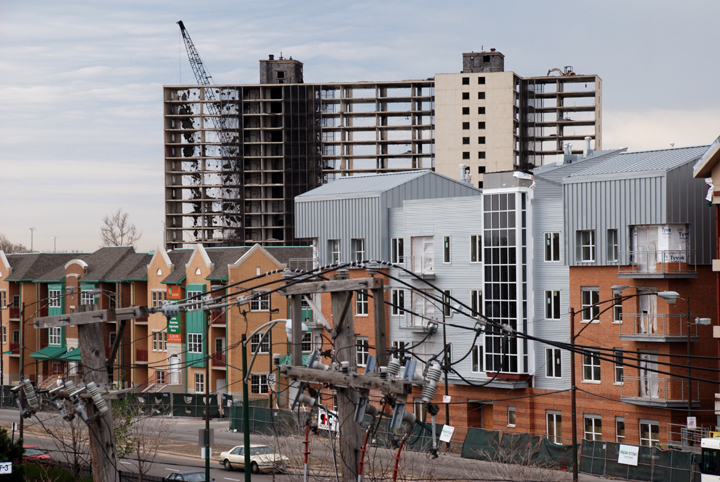 |
| Demolition of last building of Stateway Gardens housing Project, April, 2007 |
Most of us today see this as a vast improvement.
It would be interesting to come back in fifty years to see if we still feel that way.
One can only hope.
The two historical photographs made at Federal Street, come courtesy of the Gordon Koster Collection. My thanks to Al Krasauskas for posting them on the Forgotten Chicago Facebook site and inspiring this post.
 ,
,
No comments:
Post a Comment